Up to 8 feet of snow possible as whiteouts, flooding and life-threatening conditions grip Northern California
A historic and dangerous winter storm continues to batter Northern California Tuesday night, forcing the full closure of Interstate 80 and Highway 50 in both directions into and out of the Sierra Nevada, triggering an avalanche emergency near Truckee and flooding roadways across the Sacramento Valley as heavy rain falls at lower elevations.
Authorities are delivering a blunt and urgent warning: stay out of the Sierra.
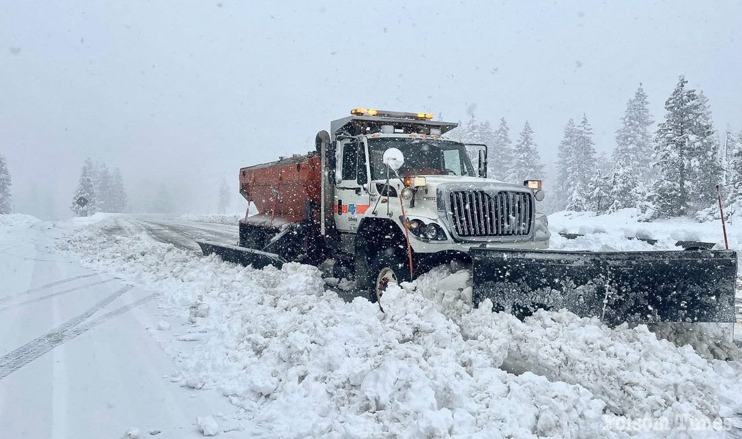
Both Interstate 80 and Highway 50 remain closed in both directions with no estimated time for reopening as heavy snow, extreme whiteout conditions and repeated spinouts make travel impossible. State Route 88 is also shut down, cutting off another major access point into the mountains.
Interstate 80 is closed from Colfax in Placer County to the Nevada state line due to heavy snowfall and near-zero visibility. Eastbound tractor-semitrailer combinations are being stopped at Applegate because of traction concerns. Chain controls are in effect from 3.4 miles east of Gold Run to the Nevada state line for all vehicles except four-wheel-drive vehicles equipped with snow tires on all four wheels. All westbound trucks are required to stop at the brake check area approximately one-half mile west of Nyack to reduce the risk of brake fires on steep grades during prolonged braking.
Highway 50 is closed from Point View Drive in Placerville to Meyers in El Dorado County because of multiple spinouts and hazardous roadway conditions. Chain controls are required from approximately nine miles east of Placerville to Meyers for all vehicles except properly equipped four-wheel-drive vehicles.
State Route 88 is closed from Dew Drop in Amador County to five miles west of Picketts Junction in Alpine County due to the storm.
Transportation officials say snowfall rates, low snow levels and constant vehicle incidents have made it impossible to safely maintain traffic flow. Motorists are advised to avoid the area entirely. There are currently no reopening estimates for Interstate 80, Highway 50 or State Route 88.
Snow is falling across virtually all Sierra elevations. Snow levels are hovering between 1,000 and 3,000 feet and have dropped even lower in heavier snow bands. Communities well below traditional mountain pass elevations are now seeing accumulating snowfall. Foothill areas that often experience rain during winter systems are reporting measurable snow, eliminating the typical transition zone that sometimes allows limited travel.
Forecasters say snow levels are expected to remain exceptionally low through the duration of the storm, preventing any safe travel windows.
In just the past 24 to 48 hours, snowfall totals have been staggering.
The Central Sierra Snow Lab has recorded more than 28 inches of new snow. Sugar Bowl Resort has reported 33 inches over the past 48 hours. Palisades Tahoe logged 29 inches on the upper mountain and 18 inches at the base. Sierra-at-Tahoe recorded 26 inches at the summit in the last 24 hours. Soda Springs has received at least 30 inches in a single day.
Snow is falling at rates of 3 to 4 inches per hour near Donner Summit, producing blinding whiteout conditions. Visibility in some areas has dropped to near zero.
The National Weather Service is strongly discouraging all non-essential mountain travel, warning that conditions are life-threatening and that emergency resources are already engaged.
While the Sierra is being buried under feet of snow, the Sacramento Valley continues to receive steady rain, causing flooding on multiple roadways and creating hazardous driving conditions across the region. Emergency crews are responding to stranded vehicles, water-covered streets and localized flooding concerns as runoff increases.
Compounding the danger, an avalanche near Castle Peak, a popular backcountry skiing area near Truckee, has left 10 skiers missing and six others stranded as rescuers attempt to navigate extreme weather conditions.
According to the Nevada County Sheriff’s Office, the avalanche occurred around 11:30 a.m. Tuesday in the Castle Peak backcountry area. The slide involved a group of 16 skiers, including four mountain guides and 12 clients. Six skiers survived and remain at the site awaiting rescue. Ten others remain unaccounted for.
Authorities said the avalanche was reported by a mountain guide service and separately through an emergency beacon device. As of Tuesday evening, approximately 46 rescuers were working to reach the group but had not yet arrived due to deep snow, unstable terrain and dangerous access routes.
The sheriff’s office remains in communication with the surviving skiers through an emergency satellite messaging system, allowing text communication as they await help.
A high-risk avalanche warning remains in effect across the Lake Tahoe backcountry. Officials say the combination of rapid snow accumulation, high winds and unstable snowpack has created extremely dangerous avalanche conditions throughout the region.
Looking ahead, forecasters say the storm is far from over.
An additional 2 to 3 feet of snow is expected by Wednesday night, with higher elevations potentially seeing total storm accumulations reach 7 to 8 feet by Thursday. Heavy snow will continue at intense rates near the passes, while snow levels are forecast to remain below 3,000 feet — and occasionally lower — through at least midweek.
In the foothills, periods of heavy snow are possible, while the valley is expected to continue receiving steady rain that may exacerbate localized flooding concerns.
Meteorologists say travel conditions are unlikely to improve in the immediate future, and additional closures or extended shutdowns remain possible as the storm cycle continues.
With major interstates closed, avalanche danger at critical levels, snow falling at all elevations and several more feet forecast, authorities are urging residents to postpone all Sierra travel and avoid recreational trips into the mountains.
“This is not the time to head to the Sierra,” emergency officials reiterated Tuesday evening. “Conditions are extreme, rescue crews are engaged and the storm is still intensifying.”
Officials encourage residents to monitor updates from Caltrans, local sheriff’s offices and the National Weather Service before attempting any travel.
For now, the message is unequivocal: stay out of the Sierra until this historic storm passes.
Copyright © 2026, Folsom Times, a digital product of All Town Media LLC. All rights reserved. No portion of this publication may be reproduced, distributed, or transmitted in any form or by any means, without the prior written permission of the publisher.


