
Police say recent arson arrest unrelated; air quality a concern in some areas
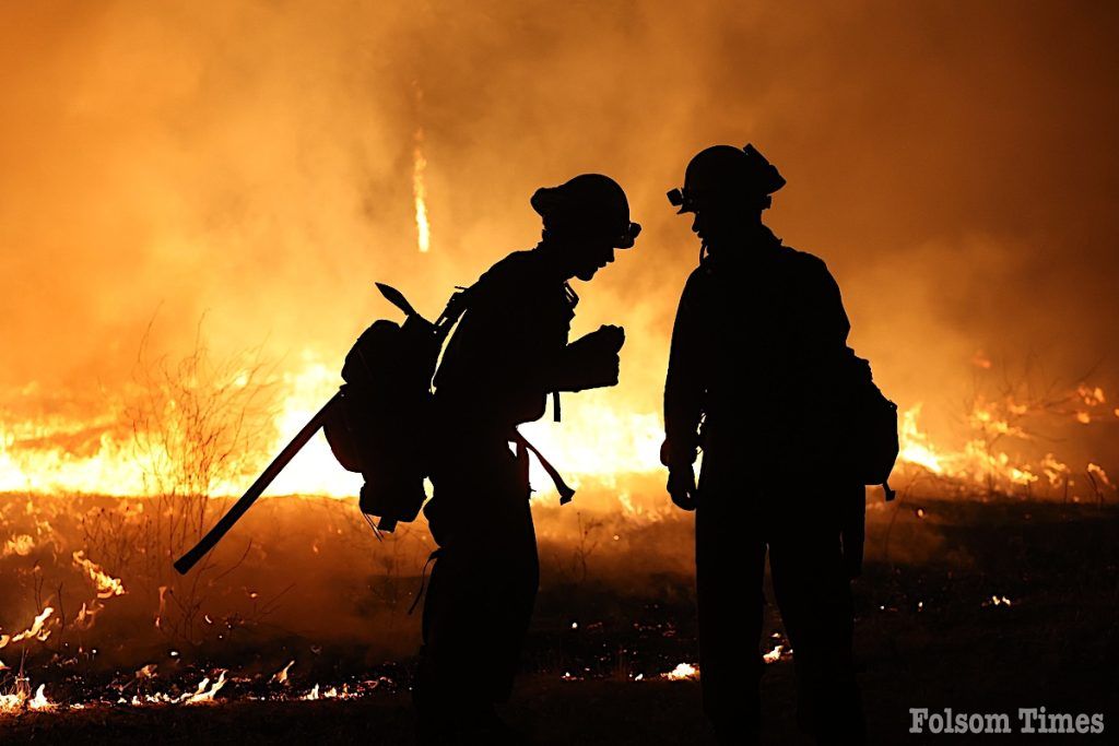
Firefighters in nearby El Dorado County continue to battle the flames of The Crozier Fire. While the efforts of firefighters managed to hold the fire to its current footprint Thursday night, according to officials, it has continued to grow in size and poses a threat to more than 1600 structures in multiple communities that remain under evacuation orders as of Friday.
The Crozier fire first ignited in the early morning hours of Aug. 6 near Slate Mountain and rapidly expanded, burning some 1,900 acres as of Friday afternoon. The fire, which remains under investigation, has prompted a massive response multiple agencies on the ground and in the air as they work to contain the blaze in the rugged terrain of the forest. Despite their efforts, containment remains low at 5%, and the fire’s path continues to threaten numerous structures and communities in the area.
Firefighters are reportedly working in a challenging environment, according to the latest reports from the California Department of Forestry and Fire Protection (CalFire) that explained the fire continues to burn if very heavy timber, thick brush, and steep, inaccessible terrain have made suppression efforts difficult. The fire is burning in a remote part of the forest, and the combination of high daytime temperatures, gusty winds, and low humidity has created conditions conducive to rapid fire spread.
Crews are actively engaged in a full suppression strategy, deploying a wide array of resources including air tankers, helicopters, and ground crews. These resources have been vital in slowing the fire’s advance, but the unpredictable nature of the fire has kept responders on high alert.
“The fire is burning in a remote part of the forest within heavy timber, thick brush and difficult access. Crews are actively engaged in a full suppression strategy including air tankers, helicopters, and ground resources,” CalFire reported in its Friday morning briefing. “The hot daytime temperatures, gusty winds and low humidities are causing elevated fire activity. A type 1 incident management team has been assigned.”
As of now, 1,625 structures are threatened by the fire, though none have been reported as destroyed or damaged. The area remains under close watch, with firefighters working around the clock to protect these vulnerable homes and buildings. The severity of the situation has led to the assignment of a type 1 incident management team, which is expected to take over the command of operations today, bringing additional expertise and coordination to the firefighting efforts.
The fire’s impact on local communities has been significant, with mandatory evacuation orders issued for the Mosquito and Swansboro communities, as well as areas east of Highway 193, Georgetown, Volcanoville, and Quintette. These areas are at high risk, and residents have been urged to leave immediately to ensure their safety. The evacuation warnings extend to a broader area surrounding the fire, where residents have been advised to be prepared to evacuate at a moment’s notice. The Perimeter Map website provides the most current and detailed information on evacuation zones, and residents are encouraged to check it frequently as the situation evolves.
VIEW THE LIVE EVACUATION PERIMETER MAP HERE FOR THE LATEST ORDERS, WARNINGS
Due to the need for fire operations, the Placerville Airport has been closed to all activity outside of fire aircraft use.
In response to the evacuations, Cameron Park Community Services District, located at 2502 Country Club Drive, Cameron Park, CA, has been established as an evacuation center, providing shelter and support to those displaced by the fire. Road closures have been implemented to ensure the safety of the public and to facilitate firefighting operations.
These closures include Mosquito Road at Rock Creek Road, Rock Creek Road at Trail Gulch Road, Highway 193 at Shoemaker Road, Eastbound Wentworth Springs Road at Citabria Lane, and Westbound Wentworth Springs Road at Stumpy Meadows Reservoir. Additionally, an animal shelter has been set up at Animal Control, 6435 Capitol Avenue, Diamond Springs, CA, for those evacuating with pets.
The firefighting effort is extensive, involving 1,556 personnel who are working tirelessly to contain the blaze. They are supported by a substantial number of resources, including 138 engines, 32 water tenders, 12 helicopters, eight hand crews, and seven bulldozers, with air tankers being deployed as needed. The coordination between CAL FIRE’s Amador-El Dorado Unit, the Eldorado National Forest, California Highway Patrol, and the El Dorado County Sheriff’s Office is crucial in this large-scale operation.
Despite the best efforts of these agencies, the unpredictable nature of the fire means that full containment remains uncertain. The coming days will be critical as firefighters continue to battle the blaze under challenging conditions. Local residents are urged to stay informed and follow all evacuation orders and warnings to ensure their safety as the situation continues to develop.
Arson arrest said to be unrelated
The Placerville Police Department reported on Thursday that officers had made an arson arrest close to the time the Crozier Fire started.
Several social media posts have reportedly shared misinformation regarding the arrest of the suspect that was made near Rock Creek Road. However, the department clarified that the arrest does not appear to be connected to the fire at this time. The specific cause remains under investigation.
Air quality a growing concern
The growing fire has also led to concerns about air quality in the surrounding areas. Due to the smoke from the Crozier Fire, the Placer County Health and Human Services team and the Air Pollution Control District issued a joint air quality advisory through August 11.
Officials have warned that smoke is expected to impact the Lake Tahoe area during the afternoon and evening hours. As winds shift, the smoke is predicted to move into the lower foothill areas overnight and into the morning, with Auburn, Colfax, and Foresthill identified as areas of concern. In response to these conditions, the county has deployed portable air cleaners to libraries in Rocklin, Auburn, Colfax, Foresthill, and Kings Beach, as well as to the Health and Human Services Center in North Auburn, to help mitigate the impact of the smoke on residents.
More fire, evacuations now underway south in Tuolumne
Meanwhile, further south in Tuolumne County, another wildfire—the Canyon Fire—has triggered evacuation orders. The fire started shortly after midnight on Friday in a canyon off Buchanan Road near Canyon Drive and had already consumed at least 75 acres Friday morning. As of early Friday morning, the fire was at zero percent containment. According to the Tuolumne County Sheriff’s Office, active evacuations are in place for several areas, including Canyon Drive, Sunrise Drive, First Avenue, Mira Monte, Buchanan Road from Carter to the River Canyon, and all residences within Ponderosa Hills, Grizzly Mine Road, Vine Street, Baker Street, Carter Street, Madrone Street, Birch Street, and the Tuolumne Band of Mi-Wuk Indians Rancheria.
Evacuees from the Canyon Fire can seek shelter at the Tuolumne Enrichment Center, located at 102 Hospital Road in Sonora, and the Sonora Senior Center at 540 Greenley Road, which will also accept small animals. Additionally, Tuolumne County Animal Control in Jamestown is providing a small animal evacuation site at 10040 Victoria Way. For large animals and livestock, the Mother Lode Fairgrounds, located at 220 Southgate Drive in Sonora, is available.
This story was last updated at 3:45 p.m. Aug. 9


