A powerful shift in the weather pattern is set to deliver rain to the foothills, heavy Sierra snow and renewed Christmas hope for ski resorts off to a slow start
FOLSOM — After a slow and frustrating start to winter across Northern California, a dramatic change in the weather pattern is poised to deliver what the region has been waiting for: widespread rain in the foothills, heavy snow in the High Sierra and a much-needed boost to reservoirs and snowpack as the holidays approach, along with renewed hope for ski resorts still waiting for winter to arrive.
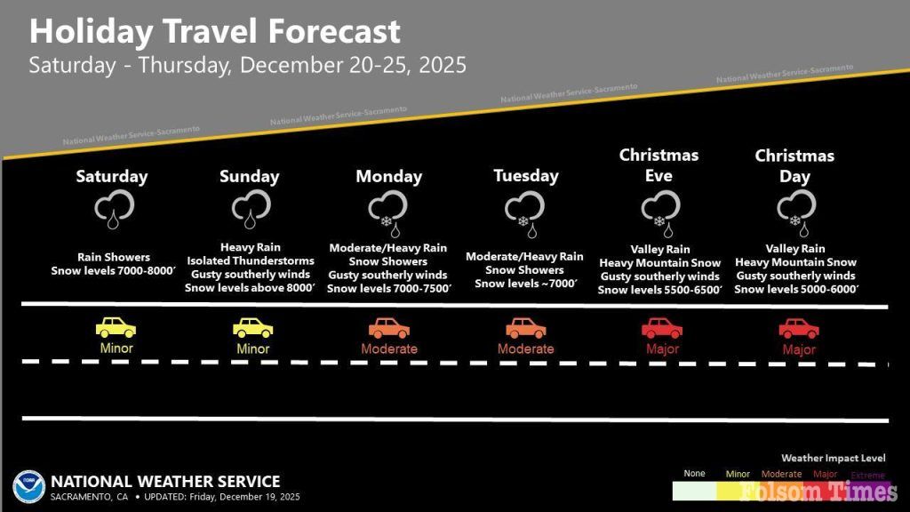
Forecasters say a series of atmospheric rivers tapping into tropical moisture — commonly known as the Pineapple Express — will begin impacting the region heading into Christmas week and continue into late December. The storms are expected to bring persistent rain at lower elevations and significant snowfall in the mountains, with some Sierra locations potentially measuring snow totals in feet by New Year’s Day.
The Mother Lode and Sierra foothills are bracing for a significant shift from recent dry conditions. The National Weather Service and Weather.com forecast daily rain in the northern Sierra foothills through the end of the year beginning Friday, Dec. 19. Some foothill communities could see more than 10 inches of rain over the next two weeks, according to forecasts, leading to rises in creeks and streams, though widespread flooding is not currently expected.
At 8:24 a.m. Friday, the National Weather Service Sacramento office issued a flood watch effective from Saturday at 4 p.m. through Friday, Dec. 26, at 4 p.m. The watch spans a broad area including the Sacramento Valley, Mother Lode, Sierra foothills, portions of Shasta County and the west slope of the northern Sierra Nevada.
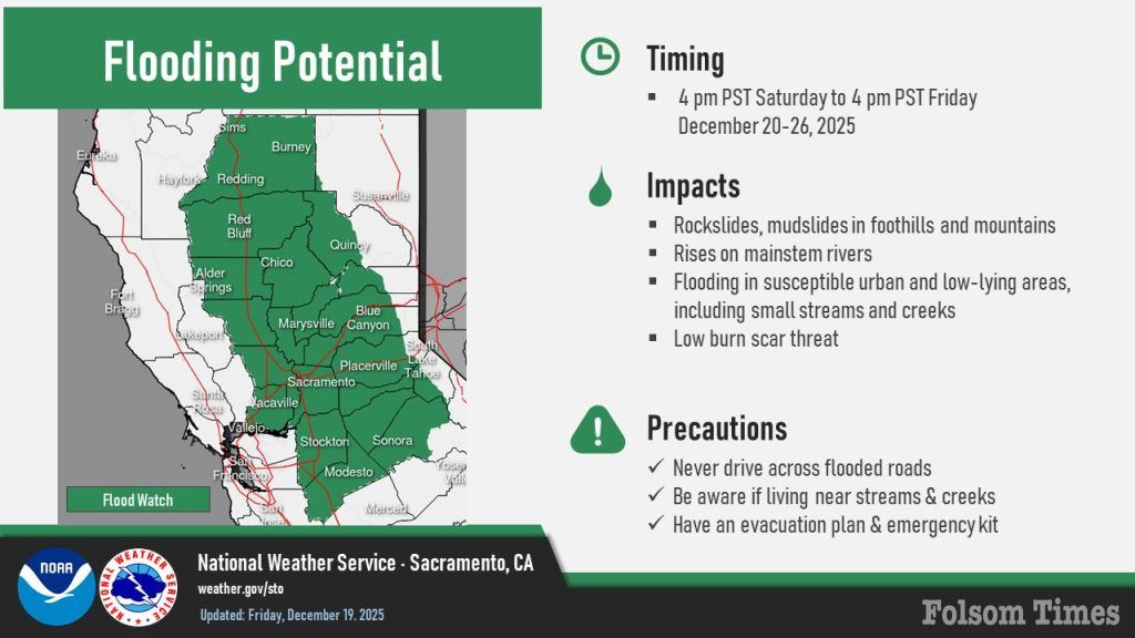
“Flooding caused by excessive rainfall is possible,” the National Weather Service stated. “Excessive runoff will result in rises along area rivers, creeks, streams. Small streams and creeks may rise out of their banks. Flooding may occur in low-lying, poor drainage, and urban areas. Mudslides and rockslides may occur in mountain and foothill areas.”
Residents in flood-prone areas are urged to monitor forecasts closely and be prepared to act should conditions worsen.
While rain brings caution at lower elevations, the same storms are expected to deliver welcome snowfall in the mountains. Weather.com predicts up to six feet of snow could fall at Donner Summit along Interstate 80 by New Year’s Day, a dramatic turnaround after weeks of sparse precipitation.
That snowfall would come as a major relief to ski resorts across the Tahoe region, where winter has gotten off to a slow and frustrating start. December has brought little to no natural snowfall, forcing resorts to rely heavily on snowmaking to stay open ahead of the holiday season.
So far in the 2026 water year, which began Oct. 1, the Central Sierra Snow Lab at Soda Springs has recorded just 22 inches of snow — about 43 percent of the median for this point in the season. The most recent measurable snowfall came on Nov. 20 and added just over an inch. While disappointing, forecasters note that slow starts occur roughly once every four years and do not necessarily predict a poor winter overall.
Several Tahoe-area resorts, including Boreal, Palisades Tahoe and Northstar, are currently open with limited beginner terrain, while others such as Sugar Bowl and Diamond Peak have yet to open. Resort officials across the region say they are watching the incoming pattern closely, noting that most of the Sierra’s snowfall historically arrives between December and February, with January often doing the heavy lifting.
Sierra at Tahoe addressed the changing forecast in its Friday morning conditions update, reflecting the cautious optimism spreading through ski country as colder air edges closer.
“Today, expect rain showers with a 70% chance of precipitation and wind gusts up to 29 mph. Snow chances tomorrow and through the weekend will depend on colder temps—so keep those snow dances, prayers, and manifestations coming. We’ll take all the help we can get!” the resort stated.
The resort said its opening day for the 2025–26 season has not yet been determined, but emphasized that preparations are ready once temperatures allow.
“Our Opening Day for the 2025/26 season is still to be determined, but you can count on us to share updates the moment we know more,” the statement continued. “We’re just waiting on Mother Nature to deliver colder temperatures so we can fire up snowmaking and get things rolling.”
Long-range weather models are now reinforcing that optimism. Forecasts are increasingly aligned in showing a wetter pattern developing over the next two weeks, with early systems possibly bringing rain at higher elevations before colder air moves in and turns precipitation to snow. Looking toward Christmas week, forecasters say conditions could line up for a more significant storm, with even conservative scenarios pointing to measurable snowfall and wetter models suggesting the potential for much more.
Beyond recreation, the incoming storms carry broader importance for Northern California. Increased precipitation will help replenish reservoirs, improve soil moisture and rebuild the mountain snowpack that serves as a natural water storage system heading into spring and summer, following a concerningly dry early winter.
For travelers heading into the Sierra during the holiday period, officials warn that wet roads, gusty winds, chain controls and temporary closures are likely, particularly as heavier snow arrives at higher elevations. Up-to-date highway conditions for Highway 50 can be found through Caltrans athttps://roads.dot.ca.gov/roadscell.php?roadnumber=50.
As Christmas approaches, the storms bring both caution and promise — a reminder that while winter weather can disrupt travel and daily routines, it also delivers the water and snow California depends on, and with it, a sense of Christmas hope for ski resorts and mountain communities waiting for winter to finally arrive.
Copyright © 2025, Folsom Times, a digital product of All Town Media LLC. All rights reserved. No portion of this publication may be reproduced, distributed, or transmitted in any form or by any means, without the prior written permission of the publisher.

