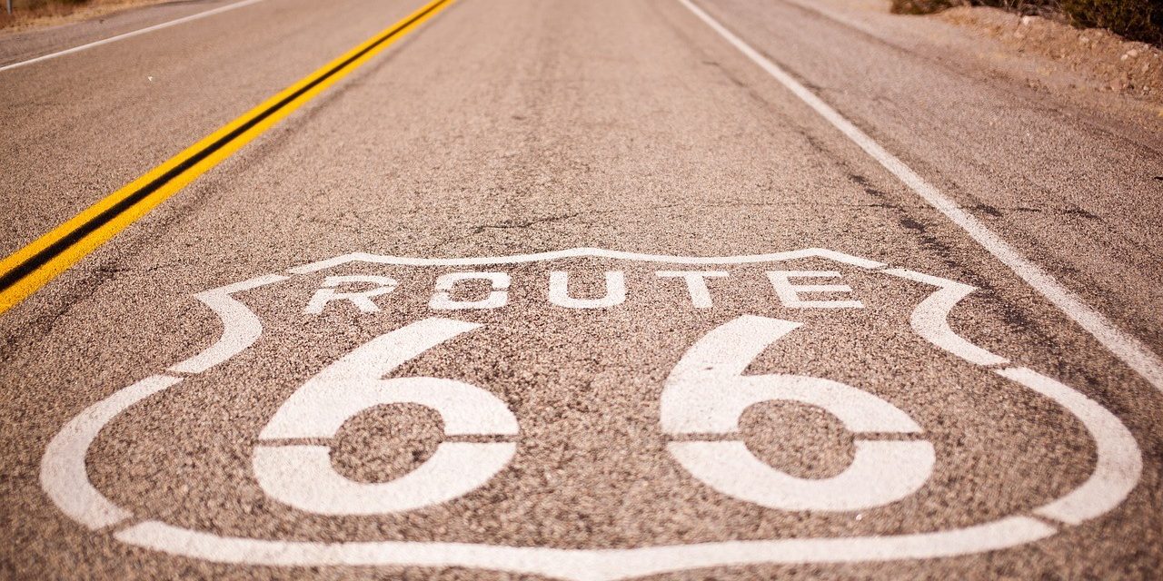
If any stretch of highway embodies the American dream—and California’s central role in it—it has to be Route 66.
First commissioned in 1926, the roughly 2,400-mile thoroughfare was built to connect Chicago and Los Angeles, spanning eight states and hundreds of small towns in between. Even though the road was decommissioned decades later, it has left both literal and figurative marks on the landscape—as well as a path that’s still easily explored. As the Route 66 Centennial Commission prepares to celebrate the 100th birthday of the highway in 2026, it’s clear that the “Mother Road” is still a living piece of American history.
The History of the Mother Road
Route 66 was originally constructed so that farmers and truckers could transport their goods more easily between small towns and big cities. While it first opened in 1926, it wasn’t fully paved until 1938, the result of a New Deal initiative that hired unemployed workers to finish the job during the Depression.
Along the way, the highway became something of a cultural touchstone. John Steinbeck’s novel The Grapes of Wrath in 1939 (and the movie in 1940) played a part in immortalizing the Mother Road, as Steinbeck called it, in chronicling a Dust Bowl family’s journey from Oklahoma to the Golden State. The highway’s mythic status was further cemented by Nat King Cole’s 1946 hit song “(Get Your Kicks On) Route 66” and a TV series in the 1960s.
During World War II, the road offered an express lane for war-effort supplies and personnel, but by the 1950s, Route 66 had become a magnet for leisure travelers. Dining and lodging had gradually developed along the highway: First, in the form of “auto camps”— parking lot–style campgrounds just off the road—followed by motels, gas stations, and diner-style restaurants. Today, you can experience a modernized version of those original lodgings at AutoCamp glamping resorts, located elsewhere in California and comprised of nicely outfitted Airstream trailers.
By the 1960s, however, the actual Mother Road was starting to fade. President Eisenhower’s Federal Aid Highway Act of 1956 created the interstate highway system, and the Mother Road was gradually superseded by newer roads and then decommissioned as a national highway. The last section of the original Route 66 was bypassed by Interstate 40 in 1984.
How to Drive Route 66 Today
Route 66 has not totally vanished, however. According to the National Trust for Historic Preservation, about 85 percent of the road is actually still drivable—it just exists under a variety of other official names and numbers, though sometimes marked with a “Historic Route 66” sign.
In California, you can trace the old Route 66 by taking a road trip from Santa Monicato the Mojave National Preserve, traveling through Los Angeles and San Bernardinocounties. To chart your trip, download the Route 66 Navigation App,which offers turn-by-turn directions along the entire length of the Mother Road, including both famous stops and hidden gems.
Definitely stop at the two California museums devoted to the highway. The California Route 66 Museum in Victorville offers a deep collection of photos, antiques, and vintage cars, including a 1917 Model T Ford. In Barstow, the Route 66 Mother Road Museum, housed in a 1911 hotel, has its own period road signs, photos, and other mid-century memorabilia.
Unique Stops Along Route 66 in California
Today’s incarnation of Mother Road is often hidden in plain sight too. In Los Angeles County, Route 66 lies along other famously named streets, such as Sunset Blvd. and Santa Monica Blvd., including parts of Beverly Hills. On New Year’s Day each year, the Tournament of Roses Parade goes down Pasadena’s Colorado Blvd., another stretch of the original Route 66.
Other stops on the road, listed below from east to west, embrace their Route 66 history while also offering interesting places to eat, sleep, and explore:
Fender’s River Resort, Needles
This Needles motel and campground, just east of the California-Arizona state line, boasts of being located on both Route 66 and the Colorado River. Book your room, camp site, or RV spot at this simple, 1960s-era resort and take advantage of its decks and easy river access for fishing, swimming, boating, and wave running.
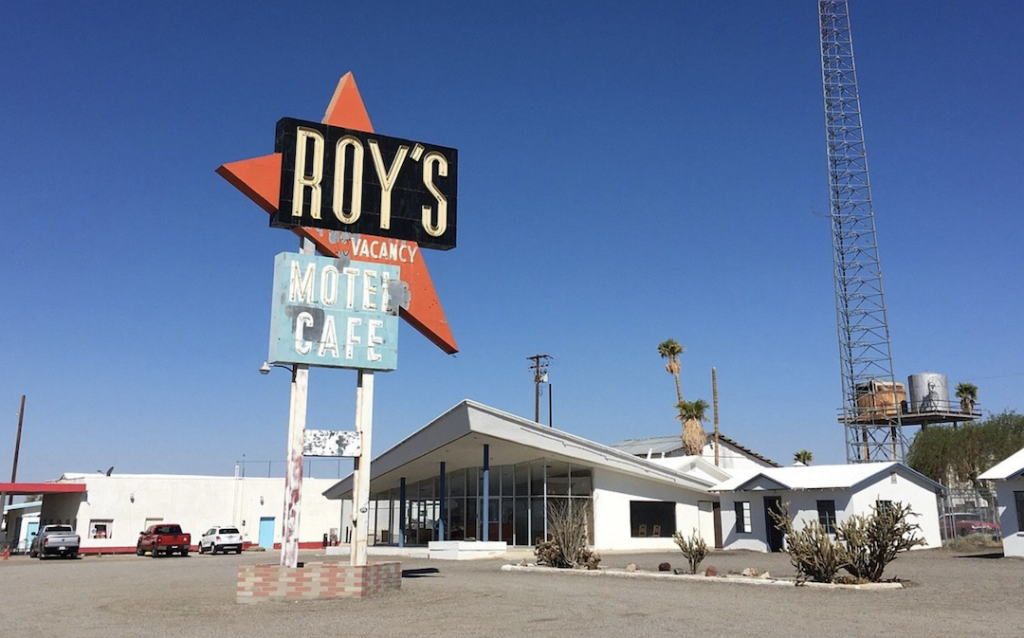
Roy’s Motel & Café, Amboy
The Jetsons-style aesthetics of this convenience store—and mostly its sign out front—will dazzle architecture nerds who consider it an excellent example of “Googie” mid-century modern design. Roy’s started out as a gas station in 1938 but added a motel, café, and auto repair shop in the 1940s. The 50-foot neon sign went up in 1959, making it easy for road trippers to spot from miles away. The town of Amboy has become something of a ghost town since then, but you can still get gas, snacks, and small versions of the neon sign in the shop. Plus, it offers a nice pit stop before visiting the 250-foot volcanic cinder cone Amboy Crater, just three miles away in the Mojave Trails National Monument.
Elmer’s Bottle Tree Ranch, Oro Grande
This quirky roadside attraction west of Barstow was created by a welder and scrap-material artist who made 200 “trees” out of colored glass bottles. Admission is free, but you can visit the wishing well in back to make a donation.
Emma Jean’s Holland Burger Café, Victorville
Refuel at this classic diner that has been serving burgers and “trucker’s special” sandwiches since 1947. The name Emma Jean was added to the sign in honor of a longtime waitress, whose husband bought the place in the 1970s. It’s found its own fame post-Route 66, appearing on Diners, Drive-Ins and Dives and in the movie Kill Bill Vol. 2.
Mitla Café, San Bernardino
This classic Mexican restaurant in San Bernardino is not just about tacos. The family-owned restaurant dates back to 1937 and offers three meals a day plus old-school ambience (superfans are partial to the chile relleno). A few blocks away, pop in at the unofficial McDonald’s Museum, a showcase of Mickey D memorabilia on the site of the first McDonald’s from 1948.
Wigwam Motel, San Bernardino
You can still stay at this motel comprised of 32-foot-high, stucco-sided teepees, built in 1949 by an entrepreneur who added a small museum and shop to show off his collection of Native American artifacts. The motel today still boasts a classic kidney-shaped pool and now also offers free coffee and WiFi. The kitschy motel has made its way into pop culture, inspiring the Cozy Cone Motel in the Disney movie Cars, and then the Cozy Cone Motel food court, part of the Cars Land area of Disneyland Resort.
Sycamore Inn, Rancho Cucamonga
An inn has sat on this San Bernardino County spot since the mid-1800s, when only a stagecoach line ran through the area. It found new life in 1939 when Danish settlers bought the inn and it soon became a Route 66 favorite; it’s still beloved for its old-school prime rib and minestrone soup, and today also offers a wine bar. Nearby, check out the Cucamonga Service Station that dates back to 1915 and is now a mini-museum showcasing photos and memorabilia.
Head to nearby downtown Ontario during September for the Route 66 Cruisin’ Reunion weekend, featuring classic cars and live music on the city’s Euclid Ave., another stretch of Route 66.
Clifton’s Republic, Los Angeles
When Route 66 opened in 1926, the highway ended at 7th St. and Broadway in downtown Los Angeles—and this neighboring restaurant became a hit when it opened in 1932. The five-level restaurant and nightclub was notable during the Depression for offering pay-what-you-will pricing and, in the 1940s and 50s, for welcoming people of all races (earning it a mention in the historic Negro Motorist Green Book). It also counted among its regulars Ray Bradbury, Charles Bukowski, and Walt Disney. Today you’ll find a collection of themed bars and quirky decor inside Clifton’s, including a tiki bar and a giant tree that’s a tribute to Muir Woods.
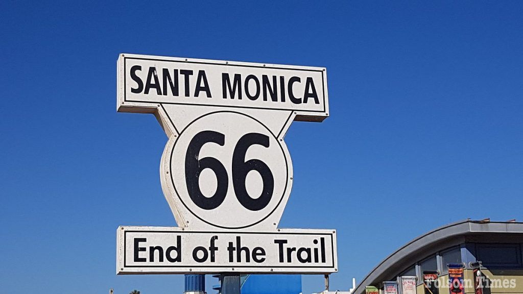
The End of the Trail Sign, Santa Monica
By the mid-1930s, the official end of Route 66 extended a little farther west, to the corner of Lincoln and Olympic in Santa Monica, where the Mother Road intersected with California’s Highway 1. The End of the Trail sign, placed in 2009, stands nearby at the Santa Monica Pier, a selfie-friendly spot next to the rides of Pacific Park.
For more Mother Road travel ideas, check out the Route 66 road trip, and this California Now Podcast episode, Route 66 and Beyond.
For more travel ideas and tips or to plan your next trip through to to California, visit www.visitcalifornia.com, the authors of this guide.

