Our sneak peak of Spring weather is coming to an end as the sun sets on Wednesday. A series of winter storms is headed our way that is expected to unleash a formidable onslaught of snow upon the Sierra and some of the foothills and bring rains to the valley in a classic “in like a lion,” way.
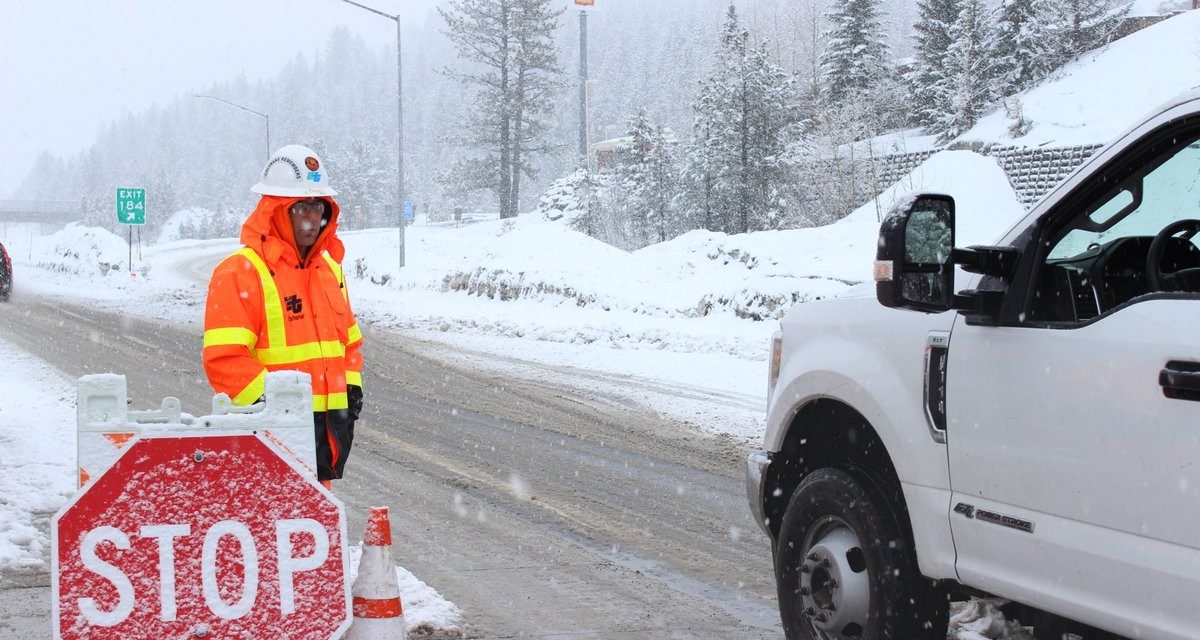
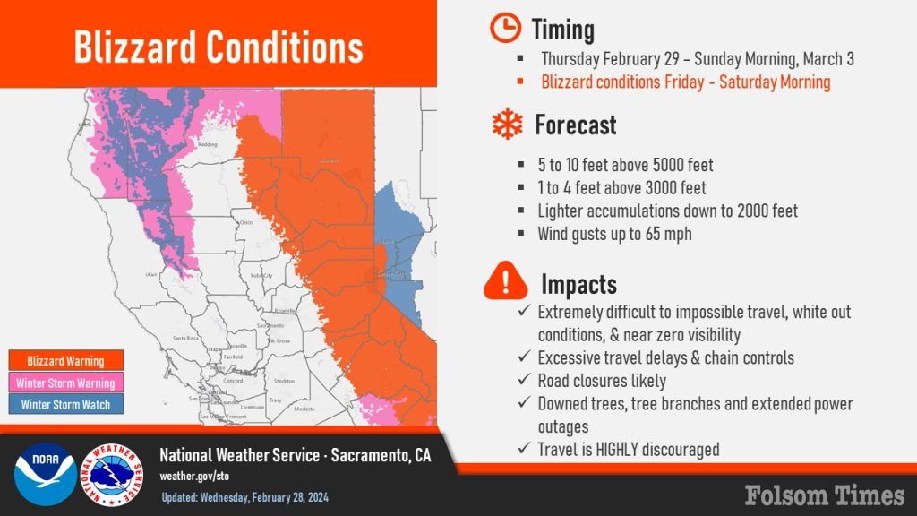
Officials from the Sacramento office of the National Weather Service are citing that treacherous mountain conditions will loom large, with blizzard warnings stretching from Thursday morning through Sunday morning in the mountains. The issued blizzard warning will be in effect for the Sierra beginning at 4 a.m. Thursday through 10 a.m. Sunday. This is just the eighth Blizzard Warning issued by the Sacramento National Weather service office since 2008.
“A strong, cold winter storm will bring extremely heavy mountain snow and blizzard conditions Thursday through the weekend, “cites the Sacramento office of the National Weather Service.” Multiple FEET of snow are forecast. Expect dangerous travel with excessive delays, whiteout conditions at times, and road closures.”
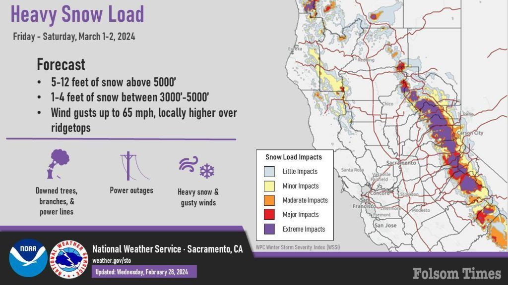
The incoming systems are said to be packing a punch unlike any seen this season, will blanket the Sierra snowfall rates at a forecasted 2-4 inches per hour, accompanied by winds gusting up to 65 mph, leading to white-out conditions and the potential for widespread power outages above 3,000 feet, according to forecasts.
Residents in the Sierra are urged to stock up on emergency supplies and ensure the functionality of vital safety equipment, such as smoke and carbon dioxide detectors, as the storm approaches. Clearing exhaust vents from debris and snow is also advised to mitigate potential hazards.
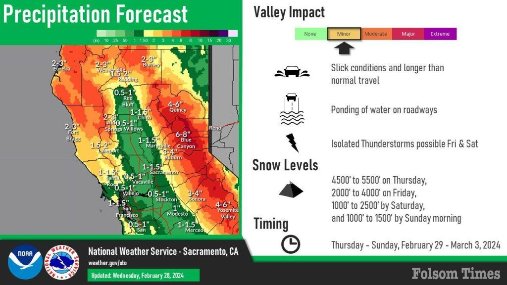
As Thursday unfolds, the system will begin its southward push, enveloping the Sierra in heavy snowfall, at rates ranging between 1-3 inches per hour. Snow levels, initially between 4,000-5,000 feet, will gradually descend to 2,500-3,500 feet by Friday, amplifying the storm’s impact.
Friday marks the crescendo of mother nature’s fury, with snowfall rates at 2-4 inches per hour, intensifying blizzard conditions and causing near-zero visibility. High winds, coupled with heavy snow, threaten tree damage and extensive power outages, particularly at elevations above 3,000 feet.
“Driving conditions will deteriorate rapidly Friday into Saturday morning, with white-out conditions, and near-zero visibility from this dangerous winter storm, avoid travel during this time,” warned the Sacramento office of the National Weather Service.“Travel should be restricted to emergencies only. If you must travel, have a winter survival kit with you. If you get stranded,stay with your vehicle.The latest road conditions for the state you are calling from can be obtained by calling 5 1 1.”
In contrast, the Sacramento Valley anticipates a milder impact, with light to moderate rainfall expected on Friday, with a slight chance of embedded thunderstorms. Roadway hazards are expected to primarily manifest as standing water and localized flooding.
Come Saturday, while the Sierra braces for the storm’s aftermath, temperatures fall, driving snow levels down to 2,000 feet, with the potential for minor accumulations. Sunday welcomes the storm’s retreat, leaving behind a blanket of snow that is expected to be between 5-10 feet above 5,000 feet and 1-4 feet above 3,000 feet in the Sierra.
Travel across the Sierra post-storm is expected to prove challenging, as crews will be working to clear snow-laden roads. While it has not been officially announced, Caltrans and other agencies could possibly make the decision to completely close down the roadways through the Sierra due to treacherous conditions. Those looking to travel to the mountains should check roadway conditions first and adjust their plans and travel prepared for heavy delays.
While it may seem like too much of a good thing in too short of a time, the expected snowfall should make a drastic improvement to the current snowpack, which has been tracking below average thus far this season.
During the second snow survey of the season at Phillips Station in early February, officials recorded 29 inches of snow depth and a snow water equivalent of 10 inches, which was 58 percent of average for the location. The snow water equivalent measures the amount of water contained in the snowpack and is a key component of DWR’s water supply forecast.
The February results reflected a modest increase in the snowpack since January 1, but overall conditions were still far below normal. DWR’s electronic readings from 130 stations placed throughout the state indicated that the statewide snowpack’s snow water equivalent is 8.4 inches, or 52 percent of average for this date, an improvement from just 28 percent of average on January 1. One year ago, the snowpack statewide was 214 percent of average in February.
Despite additional precipitation in January, many storms so far this year have been warmer than average, producing rain rather than snow at higher elevations.
Last year’s snowpack was aided by both above average precipitation and below average temperatures, which created a historic snowpack and improved reservoir storage statewide, which is still above average. DWR officials were scheduled to perform the third survey of the season next Tuesday, that has now been rescheduled to take place Thursday, March 2 in an effort to get a reading prior to the series of storms following by additional readings therafter prior to the final survey of the season next month.
Thank you for reading www.folsomtimes.com
This business article is published in Folsom Times, a product of All Town Media LLC which is locally owned and operated in the City of Folsom. The online news service was founded in 2023 by those who knew the important role that local journalism provides to the community and has become the number one online resource for Folsom area news according to all four of the major online line search engines today. In times when many local and regional news publications have shuttered or have become products that are owned and operated from afar, we remain part of community while keeping you informed of the happenings within it free of charge to the residents and readers. This is made possible by the generous support of our community advertisers and sponsors that we hope you will patronize whenever possible and thank them for supporting local news in your community. If you are interested in joining our family of advertisers or would like contribute local news releases, feel free to contact us at news@folsomtimes.com.