
Folsom Lake level 95% of normal and on the rise
A powerful winter storm is moving in and expected to impact the region this week, bringing heavy rain, strong winds, and several feet of snow in the Sierra, creating hazardous conditions for commuters and travelers.
The system will begin affecting the region late Wednesday, with light showers developing after 9 p.m. in the Sacramento and San Joaquin valleys. Rain will become widespread overnight and intensify by early Thursday morning, making for a challenging morning commute with wet roads, reduced visibility, and the potential for minor flooding in low-lying areas.
“Moderate to heavy rain will impact interior NorCal as a storm system moves through tonight-Friday,” the Sacramento office of the National Weather Service said. “Heaviest precipitation is expected Thursday and may cause minor flooding, renewed rises on area waterways, and mud/rock slides in the foothills. Never drive through flooded roads!”
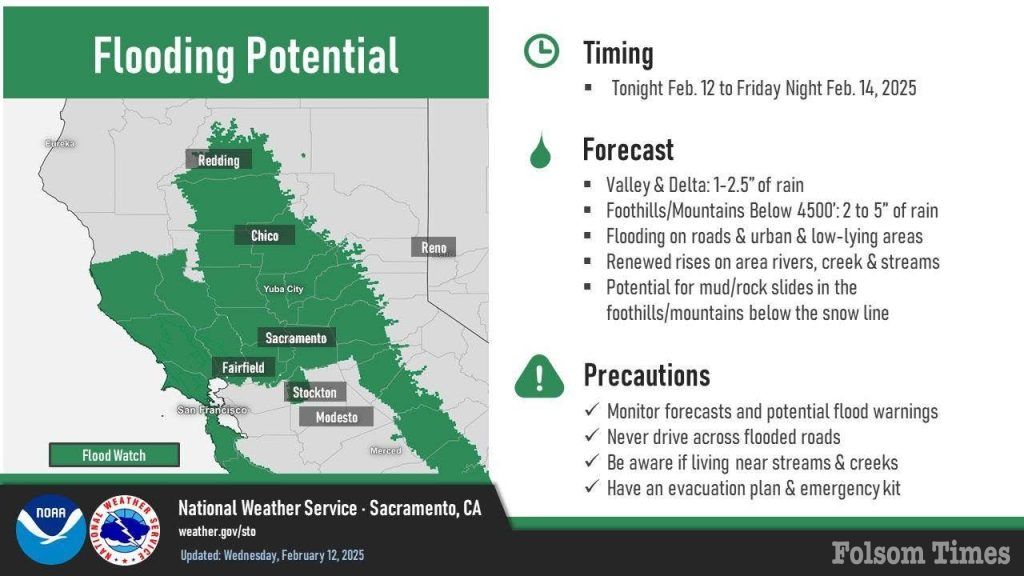
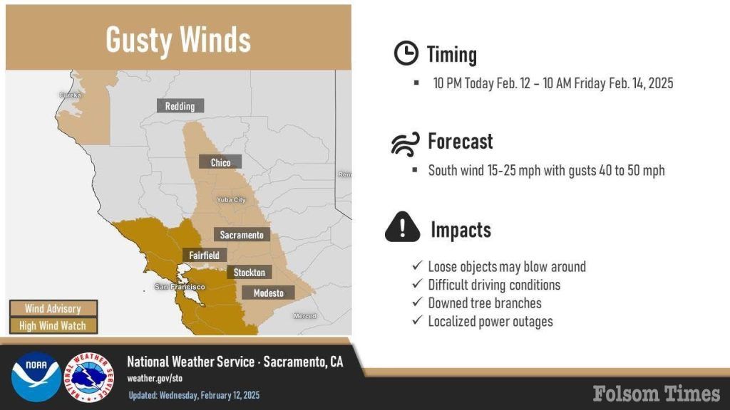
Forecasters warn that Thursday will bring the most significant impacts as the storm reaches full strength. Heavy rain, gusty winds up to 50 mph in the valley, and localized flooding are expected. A flood watch has been issued for the Sacramento Valley and surrounding foothills, where rainfall totals through Friday could reach up to 2.5 inches in the valley and as much as 6 inches in the foothills.
“Our Flood Watch goes into effect tonight and continues through the evening on Friday, Feb. 14,” the National Weather Service stated. “We’re expecting renewed rises on area rivers, creeks, and streams, as well as flooding on roads and low-lying areas.”
The influx of rain will also contribute to rising water levels in major reservoirs, including Folsom Lake, which has already seen a significant increase in early February. In just the first four days of the month, Folsom Lake gained 72,142 acre-feet of water—equivalent to more than 23.5 billion gallons. As of Feb. 5, the reservoir sat at 95% of its historical average for this time of year. Other key reservoirs in the region are also well above normal, with Lake Oroville at 135% and Lake Shasta at 130%. While these levels remain manageable, additional inflows from this storm could push water levels higher, especially as snowmelt runoff begins to factor in later in the season.
In the Sierra, travel will quickly become treacherous as snow levels start around 4,000 feet before rising to between 5,000 and 6,000 feet by Thursday afternoon. A winter storm warning is in effect for elevations above 4,500 feet, where snowfall rates of one to two inches per hour will create dangerous driving conditions. Wind gusts up to 70 mph at higher elevations will contribute to near-zero visibility, chain controls, and possible extended road closures. Motorists heading to the mountains are urged to check conditions in advance and avoid travel if possible.
Strong winds will be another factor across the region, with gusts throughout the day Thursday and peaking in the morning hours. “Our Wind Advisory remains in effect from 10 p.m. this evening through 10 a.m. Friday, Feb. 14,” the National Weather Service said. “Southerly gusts will get up to 40 to 50 mph at times. Use caution while driving and secure loose outdoor objects!”
Forecasters also warn of the potential for isolated thunderstorms as the storm moves through. “As a winter storm moves through interior NorCal the next few days, there will be a 10-20% probability of thunderstorms on Thursday,” the National Weather Service said. “With any thunderstorms that develop, you can expect lightning, gusty winds, brief heavy rain, and small hail. When thunder roars, go indoors!”
Despite the incoming snowfall, the Sierra snowpack remains below average for this time of year, though early February has brought some improvement. On Jan. 31, the statewide snowpack sat at just 65% of the historical average but has since increased to 71%. The additional snowfall from this storm will provide a much-needed boost but still falls short of typical seasonal totals.
Showers are expected to taper off Friday afternoon and evening, allowing for improved travel conditions heading into the weekend. While roads in the Sierra will likely remain slick as crews work to clear snow-covered highways, conditions in the valley will dry out by Saturday. A chance of light showers remains for Sunday in parts of the northern valley and foothills, though most areas will stay dry.
Officials advise motorists to avoid flooded roads, secure loose outdoor objects ahead of strong winds, and delay Sierra travel if possible. Travelers should stay updated on road and weather conditions as the storm progresses.


